Back مقاطعة باكز (بنسيلفانيا) Arabic Baks (dairə) Azerbaijani Bucks County, Pennsylvania BAR Бъкс Bulgarian বাকস কাউন্টি, পেনসিলভানিয়া BPY Bucks Gông (Pennsylvania) CDO Bucks County CEB شارستانی بەکس، پێنسیلڤانیا CKB Bucks County, Pennsylvania Welsh Bucks County German
Bucks County | |
|---|---|
 Bucks County Administration Building in Doylestown in 2010 | |
|
| |
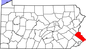
 Location within the U.S. state of Pennsylvania | |
 Pennsylvania's location within the U.S. | |
| Coordinates: 40°20′N 75°07′W / 40.34°N 75.11°W | |
| Country | |
| State | |
| Founded | November 1682 |
| Named for | Buckinghamshire |
| Seat | Doylestown |
| Largest township | Bensalem |
| Area | |
| • Total | 622 sq mi (1,610 km2) |
| • Land | 604 sq mi (1,560 km2) |
| • Water | 18 sq mi (50 km2) 2.8% |
| Population (2020) | |
| • Total | 646,538 |
| • Density | 1,070/sq mi (410/km2) |
| Time zone | UTC−5 (Eastern) |
| • Summer (DST) | UTC−4 (EDT) |
| Congressional district | 1st |
| Website | www |
| Designated | October 29, 1982[1] |
Bucks County is a county in the Commonwealth of Pennsylvania. As of the 2020 census, the population was 646,538,[2] making it the fourth-most populous county in Pennsylvania. Its county seat is Doylestown.[3] The county is named after the English county of Buckinghamshire. The county is part of the Southeast Pennsylvania region of the state.[a]
The county represents the northern boundary of the Philadelphia–Camden–Wilmington, PA–NJ–DE–MD Metropolitan Statistical Area, known as the Delaware Valley.
To its southwest, Bucks County borders Montgomery County and Philadelphia, the nation's sixth-largest city. To its east, the county borders the Delaware River and U.S. state of New Jersey. To its north, the county borders Lehigh and Northampton counties in the state's Lehigh Valley region. The county is approximately 30 miles (48 km) southeast of Allentown, the state's third-largest city, and 40 miles (64 km) north of Philadelphia, the state's largest city.
- ^ "PHMC Historical Markers Search". Pennsylvania Historical and Museum Commission. Commonwealth of Pennsylvania. Archived from the original (Searchable database) on March 21, 2016. Retrieved January 25, 2014.
- ^ "Census - Geography Profile: Bucks County, Pennsylvania". Retrieved April 24, 2022.
- ^ "Find a County". National Association of Counties. Archived from the original on May 31, 2011. Retrieved June 7, 2011.
Cite error: There are <ref group=lower-alpha> tags or {{efn}} templates on this page, but the references will not show without a {{reflist|group=lower-alpha}} template or {{notelist}} template (see the help page).
© MMXXIII Rich X Search. We shall prevail. All rights reserved. Rich X Search


