Back مقاطعة ليهاي (بنسيلفانيا) Arabic Lehigh County, Pennsylvania BAR Лихай (окръг, Пенсилвания) Bulgarian লেহাই কাউন্টি, পেনসিলভানিয়া BPY Lehigh Gông (Pennsylvania) CDO Lehigh County CEB Lehigh County, Pennsylvania Welsh Lehigh County German Condado de Lehigh Spanish Lehigh konderria (Pennsylvania) Basque
Lehigh County | |
|---|---|
 Old Lehigh County Courthouse in Allentown, built between 1814 and 1819 | |
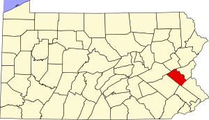
 Location within the U.S. state of Pennsylvania | |
 Pennsylvania's location within the U.S. | |
| Coordinates: 40°37′N 75°35′W / 40.61°N 75.59°W | |
| Country | |
| State | |
| Founded | March 6, 1812 |
| Named for | Lehigh River |
| Seat | Allentown |
| Largest city | Allentown |
| Area | |
| • Total | 348 sq mi (900 km2) |
| • Land | 345 sq mi (890 km2) |
| • Water | 3.1 sq mi (8 km2) 0.9% |
| Population (2020) | |
| • Total | 374,557 |
| • Density | 1,046/sq mi (404/km2) |
| Time zone | UTC−5 (Eastern) |
| • Summer (DST) | UTC−4 (EDT) |
| Congressional district | 7th |
| Website | www |
Lehigh County (Pennsylvania Dutch: Lechaa Kaundi) is a county in the Commonwealth of Pennsylvania. As of the 2020 census, the county's population was 374,557.[1] Its county seat is Allentown, the state's third-largest city after Philadelphia and Pittsburgh.[2] The county is part of the Southeast Pennsylvania region of the state.[a]
Along with Northampton County to its east, the two counties combine to form the Lehigh Valley region of eastern Pennsylvania, the third-largest metropolitan area of Pennsylvania with a population of 861,889 as of 2020. Lehigh County is one of the fastest-growing counties in Pennsylvania and the more highly populated of the two counties.[3][4] Both counties are part of the Philadelphia television market, the fourth-largest television market in the nation.
The county is named for the Lehigh River, a 109-mile-long (175 km) tributary of the Delaware River, which flows through Lehigh County. During the Industrial Revolution, the Lehigh River served a vital role in the nation's development by offering one of the first transportation and trading routes for mining products, including anthracite, iron, manganese, limestone, and ultimately manufactured steel products.
Lehigh County falls geographically between two Pennsylvania Appalachian mountain ridges, Blue Mountain to the county's north and South Mountain to its south. Lehigh County borders Montgomery County to its south, Bucks County to its southeast, Northampton County to its east, Carbon County to its north, Schuylkill County to its northwest, and Berks County to its southwest.
The county is located 64 miles (103 km) northwest of Philadelphia and 93 miles (150 km) west of New York City.
- ^ Lehigh County at U.S. Census Quick Facts
- ^ "Find a County". National Association of Counties. Retrieved June 7, 2011.
- ^ "The Lehigh Valley is growing, census numbers show," Lehigh Valley Live, August 23, 2021
- ^ Kraus, Scott (April 2, 2016). "Migration driving Lehigh Valley's recent population growth". The Morning Call. Retrieved May 17, 2017.
Cite error: There are <ref group=lower-alpha> tags or {{efn}} templates on this page, but the references will not show without a {{reflist|group=lower-alpha}} template or {{notelist}} template (see the help page).
© MMXXIII Rich X Search. We shall prevail. All rights reserved. Rich X Search

