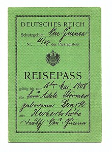
Back غينيا الجديدة الألمانية Arabic Nueva Guinea Alemana AST آلمان یئنی گینهسی AZB Германска Нова Гвинея Bulgarian Nova Guinea Alemanya Catalan Německá Nová Guinea Czech Gini Newydd Almaenig Welsh Tysk Ny Guinea Danish Deutsch-Neuguinea German Γερμανική Νέα Γουινέα Greek
German New Guinea Deutsch-Neuguinea (German) | |||||||||||||||
|---|---|---|---|---|---|---|---|---|---|---|---|---|---|---|---|
| 1884–1920 | |||||||||||||||
 German New Guinea before World War I | |||||||||||||||
| Status | German colony | ||||||||||||||
| Capital | Finschhafen (1884–1891) Madang (1891–1899) Herbertshöhe (1899–1910) Simpsonhafen (1910–1914) | ||||||||||||||
| Common languages | German (official), Unserdeutsch, Papuan languages, Austronesian Languages | ||||||||||||||
| Emperor | |||||||||||||||
• 1884–1888 | Wilhelm I | ||||||||||||||
• 1888 | Friedrich III | ||||||||||||||
• 1888–1918 | Wilhelm II | ||||||||||||||
| Governor | |||||||||||||||
• 1884–1887 | Gustav von Oertzen | ||||||||||||||
• 1901–1914 | Albert Hahl | ||||||||||||||
| Historical era | German colonisation in the Pacific Ocean | ||||||||||||||
| 3 November 1884 | |||||||||||||||
| 12 February 1899 | |||||||||||||||
| 17 September 1914 | |||||||||||||||
| 28 June 1919 | |||||||||||||||
| 17 December 1920 | |||||||||||||||
| Area | |||||||||||||||
| 1912 estimate | 249,500 km2 (96,300 sq mi) | ||||||||||||||
| Population | |||||||||||||||
• 1912 estimate | 600,000 | ||||||||||||||
| Currency | New Guinean mark | ||||||||||||||
| |||||||||||||||
| History of Papua New Guinea |
|---|
 |
|
|

German New Guinea (German: Deutsch-Neuguinea) consisted of the northeastern part of the island of New Guinea and several nearby island groups and was the first part of the German colonial empire. The mainland part of the territory, called Kaiser-Wilhelmsland, became a German protectorate in 1884. Other island groups were added subsequently. The Bismarck Archipelago (New Britain, New Ireland and several smaller islands), and the North Solomon Islands were declared a German protectorate in 1885. The Caroline Islands, Palau, and the Mariana Islands (except for Guam) were bought from Spain in 1899. German New Guinea annexed the formerly separate German Protectorate of Marshall Islands, which also included Nauru, in 1906. German Samoa, though part of the German colonial empire, was not part of German New Guinea.
Following the outbreak of the First World War in 1914, Kaiser-Wilhelmsland and nearby islands fell to Australian forces, while Japan occupied most of the remaining German possessions in the Pacific. The mainland part of German New Guinea (Kaiser-Wilhelmsland), the Bismarck Archipelago and the North Solomon Islands are now part of Papua New Guinea. The Northern Mariana Islands are an unincorporated territory of the United States. The Carolines (as the Federated States of Micronesia), the Marshall Islands, Nauru and Palau are independent countries.
The islands to the east of Kaiser-Wilhelmsland, on annexation, were renamed the Bismarck Archipelago (formerly the New Britannia Archipelago) and the two largest islands renamed Neupommern ('New Pomerania', today's New Britain) and Neumecklenburg ('New Mecklenburg', now New Ireland).[1] Due to their accessibility by water, however, these outlying islands were, and have remained, the most economically viable part of the territory.
With the exception of German Samoa, the German islands in the Western Pacific formed the "Imperial German Pacific Protectorates". These were administered as part of German New Guinea and included the Bismarck Archipelago (New Britain, New Ireland, and several smaller islands), the North Solomon Islands (Buka, Bougainville, and several smaller islands), the Carolines, Palau, the Marianas (except for Guam), the Marshall Islands, and Nauru. The total land area of German New Guinea was 249,500 square kilometres (96,300 sq mi).[2]
- ^ William Churchill, 'Germany's Lost Pacific Empire' (1920) Geographical Review 10 (2) pp. 84–90 at p. 84
- ^ "Deutsche Südsee-Schutzgebiete: Deutsch-Neuguinea, Marianen, Karolinen und Marshall-Inseln" [German South Seas Protectorates: German New Guinea, Mariana Islands, Caroline Islands and Marshall Islands]. Deutsche Schutzgebiete (in German). 12 November 2017.
© MMXXIII Rich X Search. We shall prevail. All rights reserved. Rich X Search


