Back ستيفنز (فرجينيا) Arabic ایستفنز سیتی، ویرجینیا AZB Stephens City Catalan Стивенс-Сити (Виргини) CE Stephens City CEB Stephens City Czech Stephens City, Virginia Welsh Stephens City (Virginia) Spanish Stephens City (Virginia) Basque Stephens City French
Stephens City, Virginia | |
|---|---|
 | |
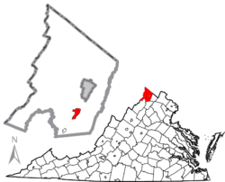
 Location in Frederick County, Virginia | |
| Coordinates: 39°4′59″N 78°13′06″W / 39.08306°N 78.21833°W | |
| Country | United States |
| State | Virginia |
| County | Frederick |
| Founded | October 12, 1758 |
| Founded by | Lewis Stephens |
| Named for | The Stephens family |
| Government | |
| • Mayor | Mike Diaz[1] |
| • Town Council | Council members |
| • Delegate | Bill Wiley (R)[2] |
| • VA Senate | Jill Holtzman Vogel (R)[2] |
| • U.S. Congress | Ben Cline (R)[3] |
| Area | |
| • Total | 2.46 sq mi (6.36 km2) |
| • Land | 2.43 sq mi (6.28 km2) |
| • Water | 0.03 sq mi (0.08 km2) |
| Elevation | 764 ft (233 m) |
| Population | |
| • Total | 2,016 |
| • Estimate (2022)[6] | 2,096 |
| • Density | 850.37/sq mi (328.37/km2) |
| Demonym | Stephens Citian |
| Time zone | UTC−5 (EST) |
| • Summer (DST) | UTC−4 (EDT) |
| ZIP code | 22655[7] |
| Area code | 540 |
| FIPS code | 51-75344[8] |
| GNIS feature ID | 1500159[9] |
| Website | stephenscity |
Stephens City (/ˈstiːvənz/ STEE-vənz) is an incorporated town in the southern part of Frederick County, Virginia, United States, with a population of 2,016 at the time of the 2020 census, and an estimated population of 2,096 in 2022.[5][6] Founded by Peter Stephens in the 1730s, the colonial town was chartered and named for Lewis Stephens (Peter's only son) in October 1758. It was originally settled by German Protestants from Heidelberg.
Stephens City is the second-oldest municipality in the Shenandoah Valley after nearby Winchester, which is about 5 mi (8 km) to the north. "Crossroads", the first free black community in the Valley in the pre-Civil War years, was founded east of town in the 1850s. Crossroads remained until the beginning of the Civil War when the freed African Americans either escaped or were recaptured. Stephens City was saved from intentional burning in 1864 by Union Major Joseph K. Stearns. The town has gone through several name changes in its history, starting as "Stephensburg", then "Newtown", and finally winding up as "Stephens City", though it nearly became "Pantops". Interstate 81 and U.S. Route 11 pass close to and through the town, respectively.
A large section of the center of the town, including buildings and homes, covering 65 acres (26 ha), is part of the Newtown–Stephensburg Historic District and was listed on the National Register of Historic Places in 1992. Stephens City celebrated its 250th anniversary on October 12, 2008. The town is a part of the Winchester, Virginia-West Virginia Metropolitan Statistical Area, an offshoot of the Washington–Baltimore–Northern Virginia, DC–MD–VA–WV Combined Statistical Area. It is a member of the Winchester–Frederick County Metropolitan Planning Organization.[10]
- ^ a b Cite error: The named reference
towncouncilwas invoked but never defined (see the help page). - ^ a b Cite error: The named reference
Legislatorwas invoked but never defined (see the help page). - ^ Cite error: The named reference
USHousewas invoked but never defined (see the help page). - ^ "2019 U.S. Gazetteer Files". United States Census Bureau. Archived from the original on October 16, 2020. Retrieved August 7, 2020.
- ^ a b "Profile of General Population and Housing Characteristics: Stephens City town, Virginia". U.S. Census Bureau, American Factfinder. Retrieved May 28, 2023.
- ^ a b Cite error: The named reference
2022censusestimatewas invoked but never defined (see the help page). - ^ "Look Up a ZIP Code". United States Postal Service. Archived from the original on May 31, 2014. Retrieved November 10, 2013.
- ^ "Geographic Identifiers: 2010 Demographic Profile Data (G001): Stephens City town, Virginia". U.S. Census Bureau, American Factfinder. Archived from the original on December 21, 2014. Retrieved January 2, 2019.
- ^ "US Board on Geographic Names". United States Geological Survey. October 25, 2007. Archived from the original on February 12, 2012. Retrieved January 31, 2008.
- ^ "Establishment of the Winchester – Frederick County ("Win-Fred") Metropolitan Planning Organization (MPO)". Win-Fred MPO. Archived from the original on August 13, 2010. Retrieved April 2, 2010.
© MMXXIII Rich X Search. We shall prevail. All rights reserved. Rich X Search
