Back Golden Horseshoe Catalan ناڵی زێڕین CKB Golden Horseshoe Czech Golden Horseshoe German Χρυσό Πέταλο Greek Ora Hufumo Esperanto Herradura Dorada Spanish گلدن هرسشو Persian Golden Horseshoe French פרסת הזהב HE
Golden Horseshoe | |
|---|---|
Secondary region | |
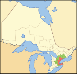
 Location of the Golden Horseshoe in Ontario. ██ Core area ██ Greater Golden Horseshoe | |
| Coordinates: 43°36′N 79°44′W / 43.6°N 79.73°W | |
| Country | Canada |
| Province | Ontario |
| Area | |
| • Total | 10,097.45 km2 (3,898.65 sq mi) |
| • Extended area | 21,464.12 km2 (8,287.34 sq mi) |
| • Combined | 31,561.57 km2 (12,185.99 sq mi) |
| Population (2021) | |
| • Total | 7,759,635 |
| • Extended area | 2,005,553 |
| • Combined | 9,765,188 |
| GDP | |
| • Combined | CA$574.7 billion[1] US$433.2 billion (2019) |
| Time zone | UTC−5 (EST) |
| • Summer (DST) | UTC−4 (EDT) |
| Postal code prefixes | |
| Area code(s) | 226, 249, 289, 365, 416, 437, 519, 548, 647, 705, 905 |
The Golden Horseshoe (French: Fer à cheval doré) is a secondary region of Southern Ontario, Canada, which lies at the western end of Lake Ontario, with outer boundaries stretching south to Lake Erie and north to Lake Scugog, Lake Simcoe and Georgian Bay of Lake Huron. The region is the most densely populated and industrialized in Canada. Based on the 2021 census, with a population of 7,759,635 people in its core and 9,765,188 in its greater area, the Golden Horseshoe accounts for over 20 percent of the population of Canada and more than 54 percent of Ontario's population.[2] It is part of the Quebec City–Windsor Corridor, itself part of the Great Lakes megalopolis.
The core of the Golden Horseshoe starts from Niagara Falls at the eastern end of the Niagara Peninsula and extends west, wrapping around the western end of Lake Ontario at Hamilton and then turning northeast to Toronto (on the northwestern shore of Lake Ontario), before finally terminating at Clarington in Durham Region. The term Greater Golden Horseshoe is used to describe a broader region that stretches inland from the core to the area of the Trent–Severn Waterway, such as Peterborough, in the northeast, to Barrie and Lake Simcoe in the north, and to the Grand River area, including centres such as Brantford, Waterloo Region, and Guelph to the west. The extended region's area covers approximately 33,500 km2 (13,000 sq mi), out of this, 7,300 km2 (2,800 sq mi) or approximately 22 percent of the area is covered by the environmentally protected Greenbelt. The Greater Golden Horseshoe forms the neck of the Ontario Peninsula.
- ^ "Statistics Canada. Table 36-10-0468-01 Gross domestic product (GDP) at basic prices, by census metropolitan area (CMA) (x 1,000,000)". Statistics Canada. May 17, 2023. Archived from the original on January 22, 2021. Retrieved June 13, 2020.
- ^ Government of Canada, Statistics Canada (2001-01-15). "Census of Population". www12.statcan.gc.ca. Retrieved 2022-02-10.
© MMXXIII Rich X Search. We shall prevail. All rights reserved. Rich X Search