Back Tamsui Czech Tamsui German Tamsui Spanish Tamsui French Thâm-súi HAK Distretto di Tamsui Italian 淡水区 Japanese 단수이구 Korean Danšujus Lithuanian Tamsui Dutch
Tamsui, Taiwan
淡水區 Tansui, Danshuei, Tanshui, Danshui | |
|---|---|
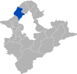
 Tamsui District in New Taipei City | |
| Coordinates: 25°10′19″N 121°26′38″E / 25.17194°N 121.44389°E | |
| Country | |
| Special municipality | New Taipei City, Taiwan |
| Area | |
| • Total | 70.65 km2 (27.28 sq mi) |
| Population (February 2023) | |
| • Total | 189,271 |
| • Density | 2,299/km2 (5,950/sq mi) |
| Time zone | +8 |
| Website | www |
| Tamsui | |||||||||||||||||||||||||||||||||||
|---|---|---|---|---|---|---|---|---|---|---|---|---|---|---|---|---|---|---|---|---|---|---|---|---|---|---|---|---|---|---|---|---|---|---|---|
 Tamsui District office | |||||||||||||||||||||||||||||||||||
| Chinese name | |||||||||||||||||||||||||||||||||||
| Chinese | 淡水 | ||||||||||||||||||||||||||||||||||
| Postal | Tamsui | ||||||||||||||||||||||||||||||||||
| |||||||||||||||||||||||||||||||||||
| Hobe | |||||||||||||||||||||||||||||||||||
| Traditional Chinese | 滬尾 | ||||||||||||||||||||||||||||||||||
| |||||||||||||||||||||||||||||||||||
| Japanese name | |||||||||||||||||||||||||||||||||||
| Kanji | 淡水 | ||||||||||||||||||||||||||||||||||
| Kana | たんすい | ||||||||||||||||||||||||||||||||||
| |||||||||||||||||||||||||||||||||||
Tamsui District[1][2][3][4] (Chinese: 淡水; pinyin: Dànshuǐ; Pe̍h-ōe-jī: Tām-chúi; Tâi-lô: Tām-tsuí) is a seaside district in New Taipei City, Taiwan adjacent to the Tamsui River and overlooking the Taiwan Strait. The name of the district means "fresh water" in Chinese. Although modest in size (population 189,271), Tamsui plays a significant role in Taiwanese history and culture.
- ^ "About Tamsui". Tamsui District Office, New Taipei City Government. Retrieved 13 July 2019.
Tamsui District
- ^ 臺灣地區鄉鎮市區級以上行政區域名稱中英對照表 (PDF). Online Translation System of Geographic Name, Ministry of Interior. 16 June 2011. p. 1. Archived from the original (PDF) on 25 March 2012.
淡水區 Tamsui District 「淡水」依國際通用、 約定俗成方式譯寫
- ^ Edward Stanford (1908). Atlas of the Chinese Empire (1 ed.). pp. 2, 13 – via Internet Archive.
Tamsui
{...}
Tamsui, Formosa . . 25.11 N 121.26 E - ^ Index to Map of China (2 ed.). Shanghai: Far Eastern Geographical Establishment. 1915. p. 86 – via Internet Archive.
Tamsui ... ... ... 儋 州 [sic] Formosa ... 臺灣 ... 25.11 N 121.26 E
© MMXXIII Rich X Search. We shall prevail. All rights reserved. Rich X Search


