Back Sint Maartin Afrikaans Isla de Sant Martín AN سانت مارتن Arabic سانت مارتن (جزيره) ARZ Islla de San Martín AST Востраў Святога Марціна Byelorussian Свети Мартин (остров) Bulgarian Enez Sant-Martin Breton Sveti Martin (ostrvo) BS Illa de Sant Martí Catalan
Nickname: The Friendly Island | |
|---|---|
 | |
 | |
| Geography | |
| Location | Caribbean |
| Coordinates | 18°05′N 63°03′W / 18.083°N 63.050°W |
| Archipelago | Leeward Islands, Lesser Antilles, Antilles, West Indies |
| Area | 88 km2 (34 sq mi) |
| Highest elevation | 424 m (1391 ft) |
| Highest point | Pic Paradis |
| Administration | |
| Overseas collectivity | Saint Martin |
| Capital and largest settlement | Marigot (pop. 5788) |
| Area covered | 53[1] km2 (20 sq mi; 0%) |
| Constituent country | Sint Maarten |
| Capital | Philipsburg (pop. 1,900) |
| Largest settlement | Lower Prince's Quarter (pop. 8,123) |
| Area covered | 34[2] km2 (13 sq mi; 0%) |
| Demographics | |
| Demonym | Saint Martiner;[3] Saint-Martinois (French); Sint Maartener (Dutch) |
| Population | 73,777[4][5] (Jan. 2019) |
| Pop. density | 847/km2 (2194/sq mi) |
| Ethnic groups | Afro-Caribbean, European, Indian, Latino, Chinese, and mixed |
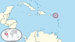
Saint Martin (French: Saint-Martin; Dutch: Sint Maarten) is an island in the northeast Caribbean, approximately 300 km (190 mi) east of Puerto Rico. The 87-square-kilometre (34 sq mi) island is divided roughly 60:40 between the French Republic (53 km2 or 20 sq mi)[1] and the Kingdom of the Netherlands (34 km2 or 13 sq mi),[2] but the Dutch part is more populated than the French part. The division dates to 1648. The northern French part comprises the Collectivity of Saint Martin and is an overseas collectivity of the French Republic. The southern Dutch part comprises Sint Maarten and is one of four constituent countries that form the Kingdom of the Netherlands. Even though the island is an overseas possession of two European Union member states, only the French part of the island is part of the EU.[6][7]
On 1 January 2019, the population of the whole island was 73,777 inhabitants, with 41,177 living on the Dutch side[4] and 32,489 on the French side.[5] Note that the figure for the French side is based on censuses that took place after the devastation of Hurricane Irma in September 2017, whereas the figure for the Dutch side is only a post-censal estimate still based on the 2011 census. The first census since Hurricane Irma on the Dutch side of the island took place in October 2022.[8] Population of the island on 1 January 2017, before Hurricane Irma, was 75,869 (40,535 on the Dutch side,[4] 35,334 on the French side[9]).
The island's traditional pre-colonial name is Oualichi which is Arawakan, meaning "the island of women".[10]
Collectively, the two territories are known as "Saint-Martin / Sint Maarten", or sometimes "SXM", the IATA identifier for Princess Juliana International Airport, the island's main airport. St. Martin (the French portion) received the ISO 3166-1 code MF in October 2007.[11] In 2010, the Dutch part had its status changed to that of a country within the Kingdom of the Netherlands and was given the code SX.[12]
- ^ a b "Mise à jour du plan de prévention des risques naturels de la collectivité territoriale de Saint-Martin" (PDF). Preferecture of Saint-Barthélemy and Saint-Martin (in French). Government of France. p. 14. Archived from the original (PDF) on 17 June 2022. Retrieved 21 February 2022.
- ^ a b "Statistical yearbook 2017" (PDF). Department of Statistics, Sint Maarten. Retrieved 21 February 2022.
- ^ "12th anniversary of St. Martin's "Unity Flag" observed Saturday on Conscious Lyrics; students raise money for unity bumper stickers". House of Nehesi Publishers. 29 August 2002.
- ^ a b c "Population Estimates and Vital Statistics 2021" (PDF). Department of Statistics, Sint Maarten. Retrieved 21 February 2022.
- ^ a b "Populations légales des collectivités d'outre-mer en 2019". INSEE (in French). Government of France. Retrieved 21 February 2022.
- ^ "EUR-Lex – 12016ME/TXT – EN – EUR-Lex". Eur-lex.europa.eu. Retrieved 24 August 2019.
- ^ "Status Caribisch gebied". netherlands.representation.ec.europa.eu (in Dutch). Retrieved 7 December 2023.
- ^ "Sint Maarten to start population census 2022 | Loop Caribbean News". Loop News. Retrieved 19 January 2024.
- ^ "Populations légales des collectivités d'outre-mer en 2017". INSEE (in French). Government of France. Retrieved 21 February 2022.
- ^ "St. Martin | The Caribbean Pet". Retrieved 6 March 2021.
- ^ ISO 3166-1 Newsletter.Assignment of code elements for Saint-Barthélemy and Saint-Martin and update of France and other French Territories.
- ^ ISO 3166-1 Newsletter. Code elements for Bonaire, Saint Eustatius, and Saba, Curaçao, and Sint Maarten (Dutch part), update of other territories and minor corrections.
© MMXXIII Rich X Search. We shall prevail. All rights reserved. Rich X Search